Färnebofjärden National Park is a Swedish national park traversed by the river Dalälven, about 140km north of Stockholm. It covers 10100ha, of which 4110ha aquatic, on the frontier between the counties of Dalarna and Gävleborg.After the retreat of the ice sheet that covered the region after the last ice age, the river found itself rerouted by an esker onto a plain uniquely ribbed by the ridges of other eskers, where it formed a succession of rapids and wide bays, which the river inundates during the spring floods. This particular hydrography, along with the park's proximity to the ecological frontier between the north and the south, has favored the development of a fauna and flora of great biodiversity. The park possesses coniferous, mixed, and broadleaf forests, some of which quite ancient, spared by the logging industry because of their inaccessibility. These forests constitute the ideal environment for numerous species, in particular birds, with critical densities of woodpeckers and owls.
 Parco nazionale Farnebofjärden
0 meter
Fantastiskt vacker del av nationalparken, jag såg många vilda djur när jag var där bl... Parque nacional de Färnebofjärden
508 meter
Väldigt vacker natur med en hel del spår efter bävrar, bra uppmärkta leder. Parc national de Färnebofjärden
508 meter
Underbart vacker nationalpark. Lättillgänglig promenadstig med tipspromenad för stora... Park Narodowy Färnebofjärden
2 km
Väldigt vacker natur med en hel del spår efter bävrar, bra uppmärkta leder.
Parco nazionale Farnebofjärden
0 meter
Fantastiskt vacker del av nationalparken, jag såg många vilda djur när jag var där bl... Parque nacional de Färnebofjärden
508 meter
Väldigt vacker natur med en hel del spår efter bävrar, bra uppmärkta leder. Parc national de Färnebofjärden
508 meter
Underbart vacker nationalpark. Lättillgänglig promenadstig med tipspromenad för stora... Park Narodowy Färnebofjärden
2 km
Väldigt vacker natur med en hel del spår efter bävrar, bra uppmärkta leder. Eaglephotography.se
11 km
We offer photography and studies of eagles from a hide in Färnebofjärden National Par...
Eaglephotography.se
11 km
We offer photography and studies of eagles from a hide in Färnebofjärden National Par...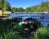 Färnebofjärdens nationalpark
12 km
Ett jättetrevlig plats att besöka, väl underhållet med byggnader o yttre skötsel. Jag... Gysinge Herrgård
12 km
Fina omgivningar. Gamla fina historiska byggnader. Boendet: Stora fina rum men slitna...
Färnebofjärdens nationalpark
12 km
Ett jättetrevlig plats att besöka, väl underhållet med byggnader o yttre skötsel. Jag... Gysinge Herrgård
12 km
Fina omgivningar. Gamla fina historiska byggnader. Boendet: Stora fina rum men slitna... Gysinge Bruk 350 år
12 km
Fina naturområden att vandra i. Lång och intressant historia? Väl värt ett besök....
Gysinge Bruk 350 år
12 km
Fina naturområden att vandra i. Lång och intressant historia? Väl värt ett besök....to add Färnebofjärden National Park map to your website;