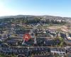
Gjelleråsen is an area which constitutes part of Oslomarka outside Oslo, Norway.The area is bordered by Skedsmo to the east and Nittedal to the north. There are many historic roads running through the area, and two modern highways, Norwegian National Road 4 to the north, and European route E6 to the south.The village of Gjelleråsen is known as a stopping point on Trondheimsveien, where Norwegian National Road 4 (Rv4) and join Norwegian National Road 22 (Rv22). Hagantunnelen on Norwegian National Road 4 starts at Gjelleråsen and at comes out at Slattum, where Norwegian National Road 4 runs north to Nittedal.The headquarters of Ringnes lies in Gjelleråsen. There is also the headquarters of Diplom-Is and the head office of Würth Norge. In the south of the area, towards Skedsmo, is the former Lahaugmoen military base. This was used as a historical stopping point for invasions, including that led by King Karl XII in 1716.The name of Gjelleråsen may come from Gjølluraas, or Gjoleid, which means "windy area", or from Gjøl - Gjel, which describes an inlet close to the road in the area. It may also come from the verb Gjalla, a sound as from an echo.
 Stovner
3 km
Stovner is a district located to the far north east of the city of Oslo, Norway. Hist... Rommen
3 km
Rommen is a Norwegian Oslo Metro station on Grorud Line between Romsås and Stovner, 1... Romsås
3 km
Romsås is a subway station on the Grorud Line of the Oslo Metro in the Grorud borough... Ammerud
4 km
Ammerud is a part of Grorud Borough in Oslo, Norway known for its large Le Corbusier ... Grorud
4 km
Grorud is a district of the city of Oslo, Norway. The district contains the Ammerud, ... Skjetten
4 km
Skjetten is a town in Skedsmo municipality, Akershus county, Norway. It is located ap... Skjetten
4 km
Skjetten er et større sted i Skedsmo kommune i Akershus fylke, med rundt 10 000 innby... Høybråtenveien
5 km
Kalbakken
5 km
Kalbakken is the station on Grorud Line of the Oslo Metro between Rødtvet and Ammerud... Furuset
5 km
Furuset is an Oslo Metro station in the Furuset borough. It is the penultimate statio... Ellingsrudåsen
5 km
Ellingsrudåsen is a subway station on the Oslo Metro, located at Ellingsrud in the Al... Rødtvet
6 km
Rødtvet is a station on Grorud Line (Line 5) of the Oslo Metro. The station is locate... Ellingsrud
6 km
Ellingsrud is a neighbourhood in the borough of Alna in the north-east part of Oslo, ... Veitvet
7 km
Veitvet is a station on Grorud Line (Line 5) on the Oslo Metro. It lies between Linde... Linderud
7 km
Linderud is a neighborhood in Bjerke borough, Oslo, Norway. The area originally forme...
Stovner
3 km
Stovner is a district located to the far north east of the city of Oslo, Norway. Hist... Rommen
3 km
Rommen is a Norwegian Oslo Metro station on Grorud Line between Romsås and Stovner, 1... Romsås
3 km
Romsås is a subway station on the Grorud Line of the Oslo Metro in the Grorud borough... Ammerud
4 km
Ammerud is a part of Grorud Borough in Oslo, Norway known for its large Le Corbusier ... Grorud
4 km
Grorud is a district of the city of Oslo, Norway. The district contains the Ammerud, ... Skjetten
4 km
Skjetten is a town in Skedsmo municipality, Akershus county, Norway. It is located ap... Skjetten
4 km
Skjetten er et større sted i Skedsmo kommune i Akershus fylke, med rundt 10 000 innby... Høybråtenveien
5 km
Kalbakken
5 km
Kalbakken is the station on Grorud Line of the Oslo Metro between Rødtvet and Ammerud... Furuset
5 km
Furuset is an Oslo Metro station in the Furuset borough. It is the penultimate statio... Ellingsrudåsen
5 km
Ellingsrudåsen is a subway station on the Oslo Metro, located at Ellingsrud in the Al... Rødtvet
6 km
Rødtvet is a station on Grorud Line (Line 5) of the Oslo Metro. The station is locate... Ellingsrud
6 km
Ellingsrud is a neighbourhood in the borough of Alna in the north-east part of Oslo, ... Veitvet
7 km
Veitvet is a station on Grorud Line (Line 5) on the Oslo Metro. It lies between Linde... Linderud
7 km
Linderud is a neighborhood in Bjerke borough, Oslo, Norway. The area originally forme...Legg til dette kortet på nettstedet ditt;

Vi bruker informasjonskapsler og annen sporingsteknologi for å forbedre din nettleseropplevelse på nettstedet vårt, for å vise deg personlig innhold og målrettede annonser, for å analysere nettstrafikken vår og for å forstå hvor våre besøkende kommer fra. Personvernregler